Edwin and Karen Clark are the longest established vendors of Antique Maps and Prints in Queensland.
Since 1989
Since 1989
Antique listings only. No reproductions are listed.
Enquiries: [email protected]
Brisbane in 1866.
Antique woodcut with later hand colouring.
Published “Illustrated London News” 1866.
View is from Wickham Tce.
The Mary McKillop church (the third oldest building in Brisbane is visible)
Framed size. 84 x 27 cm. $500 + PP
Antique woodcut with later hand colouring.
Published “Illustrated London News” 1866.
View is from Wickham Tce.
The Mary McKillop church (the third oldest building in Brisbane is visible)
Framed size. 84 x 27 cm. $500 + PP

Brisbane 1863.
Antique woodcut with later hand colouring.
Published “Illustrated London News” 1863.
View is from Wickham Tce.
The Mary McKillop church (the third oldest building in Brisbane is visible)
This panoramic view is scarce.
Framed size. 82 x 27 cm. $800. + PP
Antique woodcut with later hand colouring.
Published “Illustrated London News” 1863.
View is from Wickham Tce.
The Mary McKillop church (the third oldest building in Brisbane is visible)
This panoramic view is scarce.
Framed size. 82 x 27 cm. $800. + PP

|
Europe 1764. "Carte d'Europe Divisee en ses Empires et Roymes...", Clouet, Jean Baptiste Louis
Antique copper plate engraving with original outline colour and later hand colouring. Intense detail for a copper plate. A great study from the period just before the use of accurate longitude. Framed size. 83 x 65 cm Price. $870.00 plus PP. Free delivery in the Brisbane area. |
Below is detail from the above map around Dublin.
|
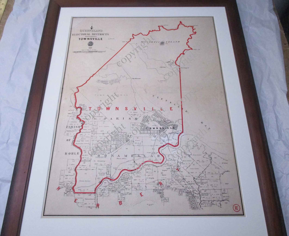
Queensland Electoral Districts. Townsville.
Antique engraving with lithographic outline. Published by the Government of Queensland. Framed size. 65 x 82 cm Rare restored map of Townsville. Minor missing section, (replaced) creasing (repaired). All information legible. All research by the vendor indicates that this map is the only known copy as neither the National Library in Canberra or any State Library in Australia lists it in their collection. It is also not to be found in and commercial online listings. 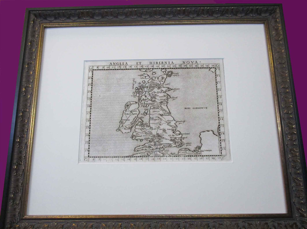
Anglia et Hibernia Nova.
Ruscelli, Girolamo. Period. c.1562. (ABOVE) Geographia Claudio Ptolemaei Alexandrini…. From the later section of the Geografia. It is adapted from George Lily's map of 1546 with distinct topographical features. The seas are stipple engraved in the Italian style. Latin text on verso. References: Mickwitz & Miekkavaara #217-5; Shirley (BI to 1650) & (MCC-94) #68 An antique copper plate engraving as published. This 450 year old map of the UK was printed some eighty years after the invention of copper plate engraving (early in the reign of Elizabeth the First), and around 50 years after the first map to use the word "America" (Waldseemuller, 1507). This century was the first to use the Mercator projection and the first to experience firearms dominating the battlefield. Free delivery in the Brisbane area. Framed size is 50 x 41 cm. UV Filtered glass. Acid free matting. $800 AUD plus P.P New Zealand.
Antique engraving (steel plate) with some original outline colouring and later hand colouring. Published by A.K.Johnston, Edinburg, c. 1853. Center fold with light toning, otherwise in very good condition. Framed size. 78 x 66 cm. (3 kg). $800 + PP 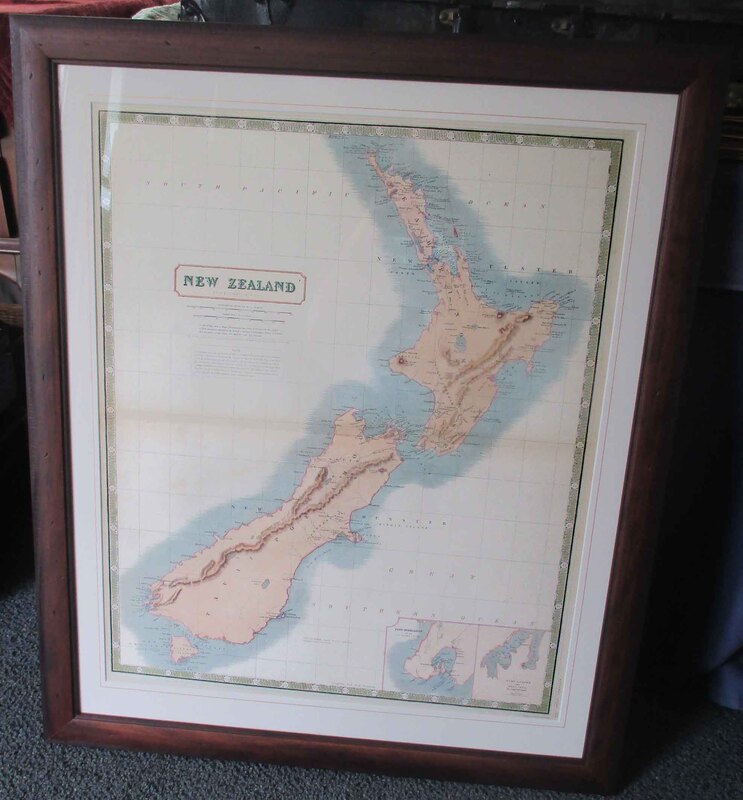
|
|
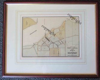
Southport Street Plan.
Antique chromo-lithograph.
Published , Brisbane. 1899.
Size 45 x 36 cm.
Price.
$200.
Antique chromo-lithograph.
Published , Brisbane. 1899.
Size 45 x 36 cm.
Price.
$200.
Antique listings. No reproductions in this column
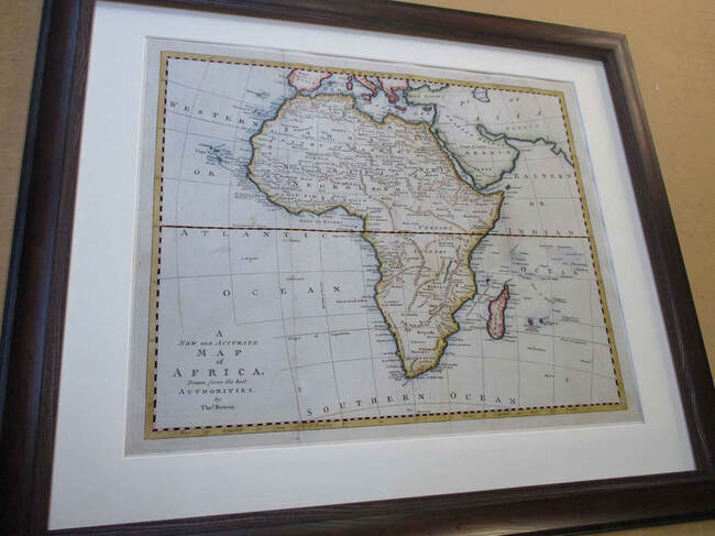
A New and Accurate map of Africa.
Antique copper plate engraving with later hand colouring.
Published by Thomas Bowen, London, 1788.
Size. 61 x 52 cm framed.
Price. $495.00 + $70.00 PP.
Free delivery in the Brisbane district.
Antique copper plate engraving with later hand colouring.
Published by Thomas Bowen, London, 1788.
Size. 61 x 52 cm framed.
Price. $495.00 + $70.00 PP.
Free delivery in the Brisbane district.
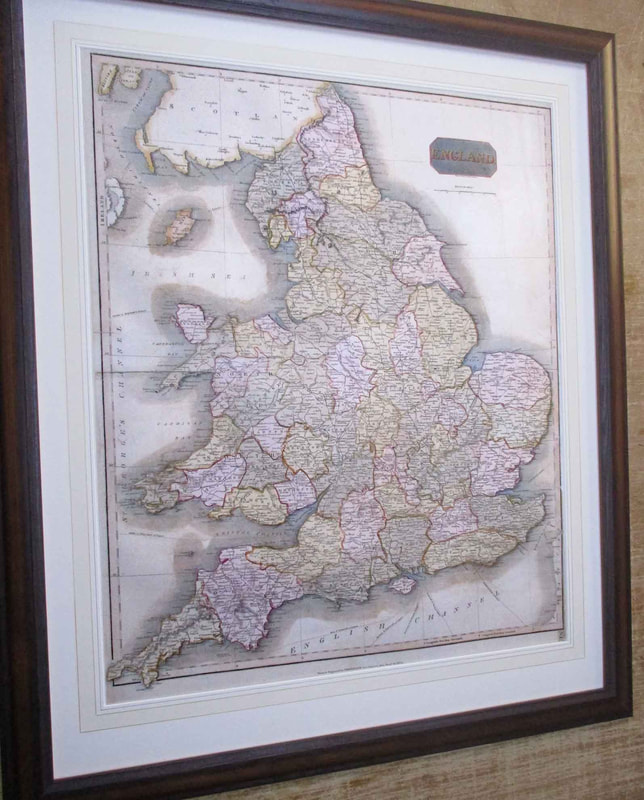
England.
Antique engraving (copper plate)
Thomson’s New General Atlas, 1814.
Center crease and some cracks. (Repaired)
Framed size 69 x 82 cm
$600.00 AUD. + PP
Antique engraving (copper plate)
Thomson’s New General Atlas, 1814.
Center crease and some cracks. (Repaired)
Framed size 69 x 82 cm
$600.00 AUD. + PP
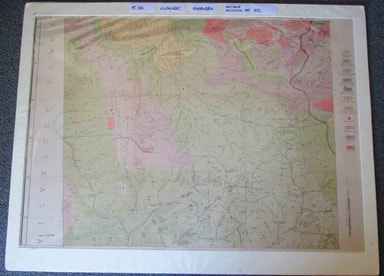
Geological map of western Queensland.
By Robert Logan Jack. 1892.
Antique lithograph printed in Queensland.
Structurally restored large map incorporating Mt. Isa , Hughenden, Boulia area.
Mt Isa is not on the map as it was founded in 1923.
Size. 77 x 101 cm matted.
Price. $400.
Photographed wrapped in cellophane
By Robert Logan Jack. 1892.
Antique lithograph printed in Queensland.
Structurally restored large map incorporating Mt. Isa , Hughenden, Boulia area.
Mt Isa is not on the map as it was founded in 1923.
Size. 77 x 101 cm matted.
Price. $400.
Photographed wrapped in cellophane
Antique listings only. No reproductions in this column
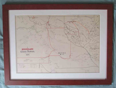
Queensland Census District 1876. 61 x 46 cm $500. +pp. Rare.
Covering from where Camooweal now is to just west of Charters Towers, the map pre-dates the towns of Cloncurry, Julia Ck, Richmond, Croydon, Hughenden and of course Mt Isa. The total population (Europeans only) was 899 .
Detail of knowledge from that time includes limited sections of rivers and creeks.
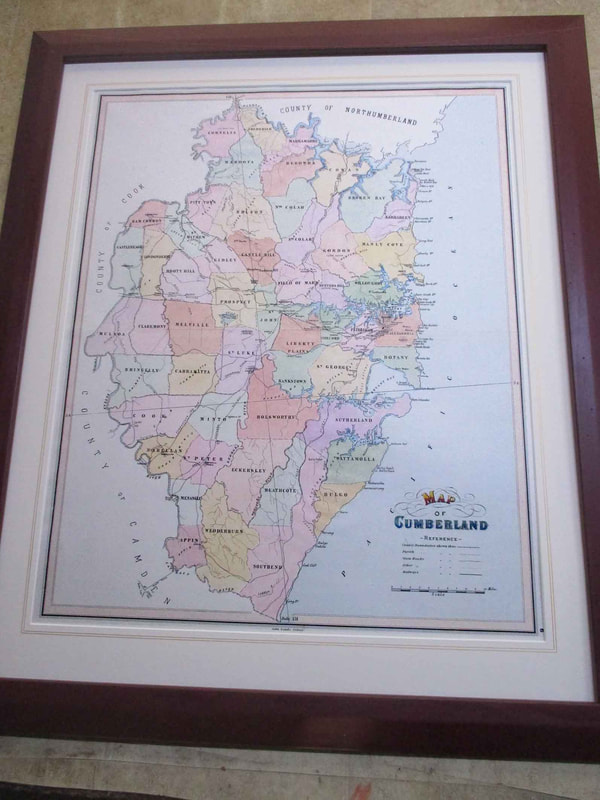
Map of Cumberland.
SYDNEY DISTRICT.
Antique chromo-lithograph.
Published by J. Sands. Sydney. 1886.
Framed size 59 x 71 cm
$400
SYDNEY DISTRICT.
Antique chromo-lithograph.
Published by J. Sands. Sydney. 1886.
Framed size 59 x 71 cm
$400
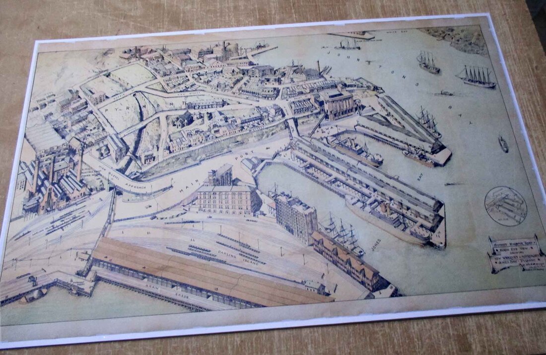
Sydney Harbour Trust.
Birds Eye View showing new wharves and approaches
Jones Bay Pyrmont.
Published by the Government of New South Wales. 1919.
Antique chromo-lithograph.
Paper size 51 x 85 cm.
Will be posted in a tube.
$1000.
Birds Eye View showing new wharves and approaches
Jones Bay Pyrmont.
Published by the Government of New South Wales. 1919.
Antique chromo-lithograph.
Paper size 51 x 85 cm.
Will be posted in a tube.
$1000.
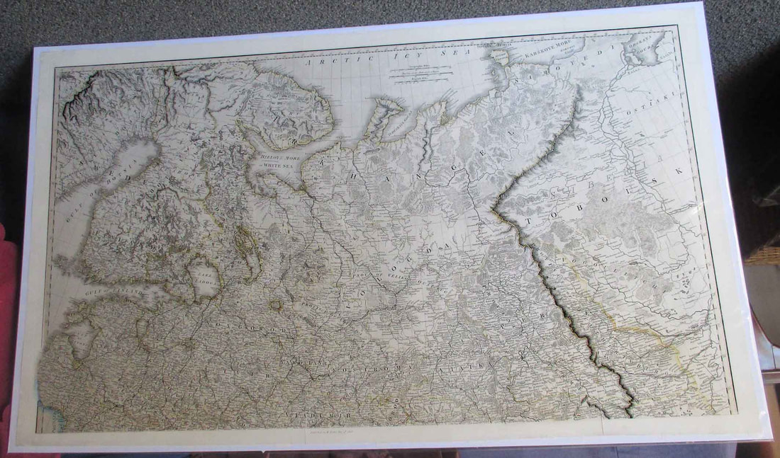
Norther Russia incorporating sections of Sweden, Finland, Estonia and Lithuania.
Antique engraving (copper plate)
With some original outline colouring.
Published by W. Faden. London. 1808.
Paper size. 97 x 58.
Sold, posted in a tube.
$450. AUD + PP
Antique engraving (copper plate)
With some original outline colouring.
Published by W. Faden. London. 1808.
Paper size. 97 x 58.
Sold, posted in a tube.
$450. AUD + PP
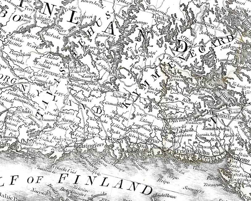
Detail sample of above map.
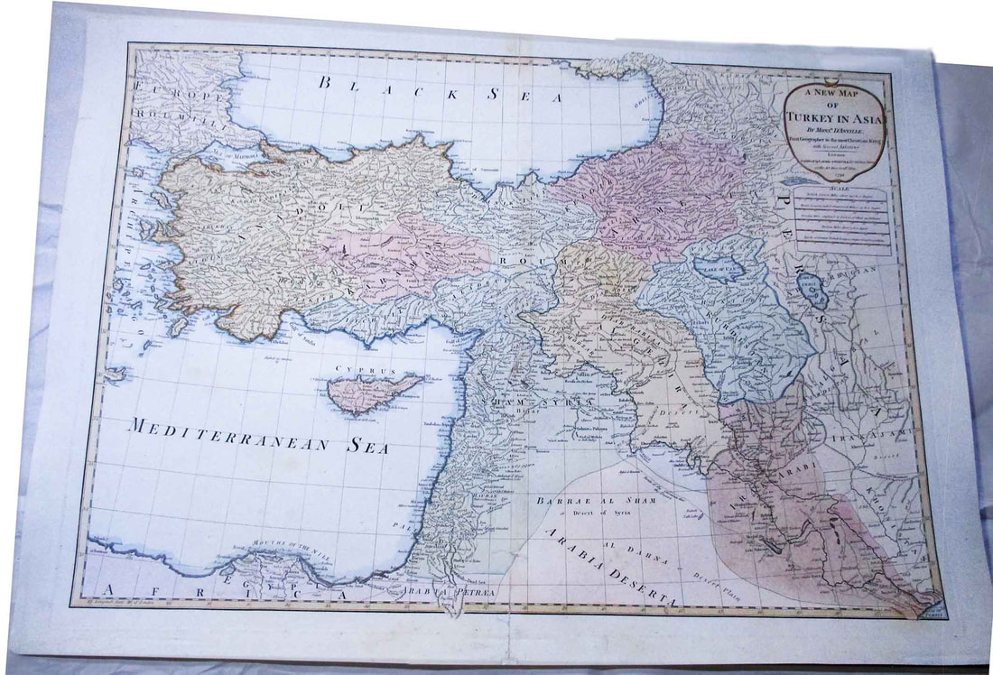
Turkey in Asia.
Antique engraving (copper plate) with original and later hand colouring.
Published by Laurie and Whittle, London , 1794.
Paper size. 79 x 57 cm.
Sold, posted in a tube.
$600.
Antique engraving (copper plate) with original and later hand colouring.
Published by Laurie and Whittle, London , 1794.
Paper size. 79 x 57 cm.
Sold, posted in a tube.
$600.
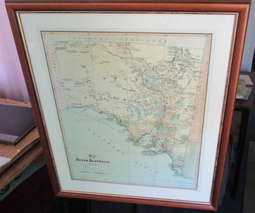
Map of South Australia. (above)
Antique chromo-lithograph.
John Sands, 1886.
$275.00. + $70.00 pp.
Antique chromo-lithograph.
John Sands, 1886.
$275.00. + $70.00 pp.
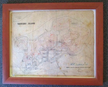
A wartime Map of Thursday Island. (1942)
50 x 61 cm
Printed onto silk with wartime annotations. $250.
No restoration . Warts and all on this one.
50 x 61 cm
Printed onto silk with wartime annotations. $250.
No restoration . Warts and all on this one.
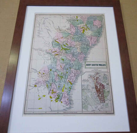
New South Wales. (Above)
Antique (steel plate) engraving with original and later hand colouring.
Published by A. Black, Edinburgh, 1853.
Size. 41 x 53 cm framed.
$275. AUD
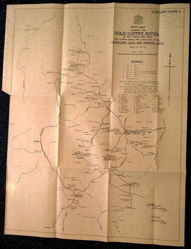
Cloncurry District. 1940. (above)
Unrestored government map showing the production ratios of different mines.
$100 as is.
Melbourne Area.
Antique chromo-lithograph with later hand colouring.
Published by John Sands, 1886. (Bendigo is shown as Sandhurst.)
Price .. $400.00. + $80.00 pp.
Antique chromo-lithograph with later hand colouring.
Published by John Sands, 1886. (Bendigo is shown as Sandhurst.)
Price .. $400.00. + $80.00 pp.
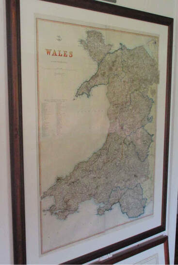
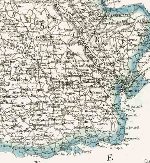
Map of Wales (Above)
Large map offered rolled in a tube.
C. 1867.
$375.00
Edwin and Karen Clark are the longest established vendors of Antique Maps and Prints in Queensland.
Since 1989
Since 1989
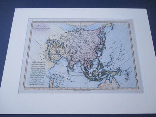
Asie. (Below)
Antique engraving (copper plate) with later hand colouring.
Pub. M. Bonne. Paris. c. 1787 "Atlas Encyclopédique"
Size matted. 48 x 54 cm.
$190 AUD. +pp.
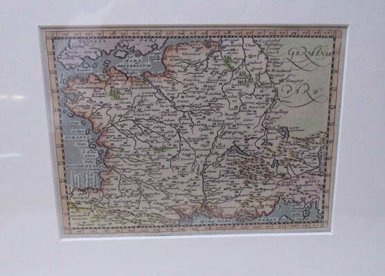
Galliae Regnvm.
(Map of France.)
Antique copper plate engraving with later hand colouring.
Pub. Magini $ Porro. 1617.
Matted size.30 x 25 cm
$100 AUD +pp
(Map of France.)
Antique copper plate engraving with later hand colouring.
Pub. Magini $ Porro. 1617.
Matted size.30 x 25 cm
$100 AUD +pp
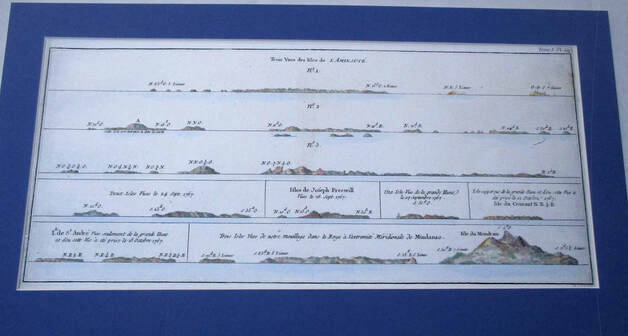
Trois Vues des Isles de L' Amiraute. No. 1. (Below)
Antique engraving with later hand colouring.
Pub. Paris. c. 1777.
Navigational profiles of the Manus Islands, PNG.
Matted size 26 x 48 cm.
$95 AUD +pp.
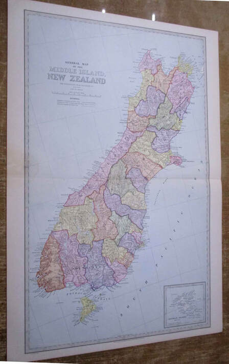
Middle (sic) Island New Zealand.
Antique chromo-lithograph.
Pub. A Garran. 1888.
Size 42 x 64cm
$200 AUD +pp.
This map and the Nt Island as a pair for $350 AUD.
Small stain on L margin.
CHINA.
“A New and Accurate Map of China.”
Antique engraving (copper plate) with original and later hand colouring.
“Drawn from surveys made by the Jefuit (sic) Missionaries by order of the Emperor.”
Published by E. Bowen. 1747. The survey lasted from 1708-17.
Contains the first broadly accurate description of Korea on a western map.
A key at the bottom right provides the meaning of relevant Chinese words.
Framed size. 50 x 59 cm. $700 + PP
.

(Netherlands) Provinces Unies des Pays Bas .
Antique engraving with original and later hand colouring. Published by Nicolas Sanson. 1648.
“Cartes Générales de Toutes les Parties de Monde “
Map of the Netherlands focuses on political boundaries, rivers, and towns.
The map extends south to Gent and Antwerp in Belgium and as far east as Dortmund and Munster
In Germany.
The North Sea is labeled Mer d’ Allemaigne. Embellished with a simple strap work cartouche.
This is the first state.
Ref: Pastoureau, SANSON V A (51)
Framed size. 66 x 57 cm. $600. + PP

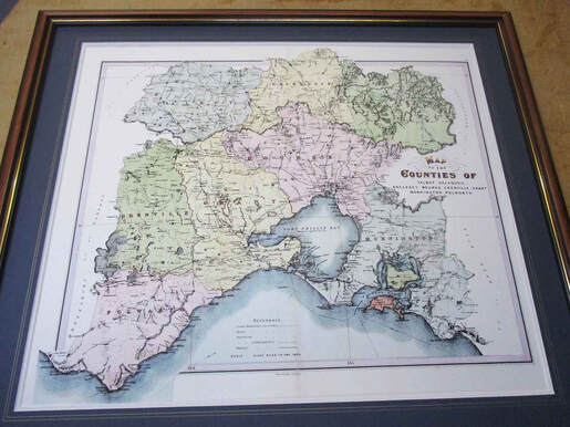
Canberra area map.
Counties of Harden, King, Argyle, Buccleugh, Murray, St Vincent, Cowley.
Antique chromo-lithograph.
Published by J. Sands. Sydney. 1886.
Note. This map pre-dates Canberra.
Map size.59 x 46 cm
Posted in a tube. $250 + PP
Counties of Harden, King, Argyle, Buccleugh, Murray, St Vincent, Cowley.
Antique chromo-lithograph.
Published by J. Sands. Sydney. 1886.
Note. This map pre-dates Canberra.
Map size.59 x 46 cm
Posted in a tube. $250 + PP

Scotland.
“Magnae Britannia Pars Septentrionalis qua Regnum
Scotia in suas Partes et Subjacentes Insulas Divisum…'
Antique engraving with later hand colouring.
Pub. By Johann Baptist Homamm , circa 1720.
Framed size. 65 x 75 cm. $800. + PP
“Magnae Britannia Pars Septentrionalis qua Regnum
Scotia in suas Partes et Subjacentes Insulas Divisum…'
Antique engraving with later hand colouring.
Pub. By Johann Baptist Homamm , circa 1720.
Framed size. 65 x 75 cm. $800. + PP
